Property Record
Bottoms Rd, Cumming, GA 30041
NEARBY LISTINGS FOR SALE OR LEASE
-
-
View all Cumming listings for lease on LoopNet.com
Property Detail
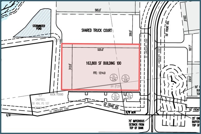
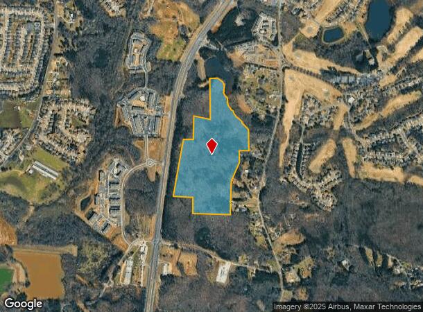
Bottoms Rd
Atlanta-Sandy Springs-Roswell, GA
Carnes Meadow
235-036
14-1 314-334-335 TR 2 ZON CHG FR HB TO M1 PER ZA4056--2023
Commercialnec
Forsyth
A
Georgia
13117C0062G
1
2024
47.07 AC
2025
N Fulton/Forsyth Cnty
130509
Atlanta
DEMOGRAPHICS near Bottoms Rd
1 Mile
3 Mile
5 Mile
2024 Total Population
4,622
22,167
55,456
2029 Population
5,325
26,072
66,172
Pop Growth 2024-2029
+ 15.21%
+ 17.62%
+ 19.32%
Average Age
37
38
39
2024 Total Households
1,534
7,362
18,852
HH Growth 2024-2029
+ 15.38%
+ 17.83%
+ 19.56%
Median Household Inc
$106,886
$109,053
$100,537
Avg Household Size
3.00
3.00
2.90
2024 Avg HH Vehicles
2.00
2.00
2.00
Median Home Value
$349,734
$372,867
$368,700
Median Year Built
2008
2006
2003
Nearby Places
Map Layers
Map Styles
 Street
 Aerial
- Restaurants
- Banks
- Shops
- Fitness
- Groceries
SALE & LEASE HISTORY
LISTING DATE
SALE/LEASE

Apr 11, 2023
For Lease
Nearby Properties
Address
Land Use
TOTAL SIZE
Lot Size
Zoning
Address
Land Use
TOTAL SIZE
Lot Size
Zoning
57,180 SF
61.71 AC
RES6
Address
Land Use
TOTAL SIZE
Lot Size
Zoning
28.74 AC
MP
Address
Land Use
TOTAL SIZE
Lot Size
Zoning
413,484 SF
127.99 AC
A1
Address
Land Use
TOTAL SIZE
Lot Size
Zoning
50,875 SF
420.29 AC
A1
Address
Land Use
TOTAL SIZE
Lot Size
Zoning
19.21 AC
M1
Address
Land Use
TOTAL SIZE
Lot Size
Zoning
152,668 SF
41.92 AC
CBD
Address
Land Use
TOTAL SIZE
Lot Size
Zoning
6,086 SF
14.85 AC
O&I
Address
Land Use
TOTAL SIZE
Lot Size
Zoning
59,534 SF
16.93 AC
CBD
Address
Land Use
TOTAL SIZE
Lot Size
Zoning
74,796 SF
9.92 AC
CBD
Address
Land Use
TOTAL SIZE
Lot Size
Zoning
54,674 SF
7.65 AC
UV
Address
Land Use
TOTAL SIZE
Lot Size
Zoning
192,550 SF
21.11 AC
CBD
Address
Land Use
TOTAL SIZE
Lot Size
Zoning
130,686 SF
41.98 AC
R2R
Address
Land Use
TOTAL SIZE
Lot Size
Zoning
80,956 SF
6.07 AC
CBD
Address
Land Use
TOTAL SIZE
Lot Size
Zoning
229.24 AC
M1
Address
Land Use
TOTAL SIZE
Lot Size
Zoning
80,497 SF
9.22 AC
CBD
Address
Land Use
TOTAL SIZE
Lot Size
Zoning
12,217 SF
3.85 AC
CBD
Address
Land Use
TOTAL SIZE
Lot Size
Zoning
39,251 SF
109.39 AC
A1
Address
Land Use
TOTAL SIZE
Lot Size
Zoning
3.90 AC
M1
Address
Land Use
TOTAL SIZE
Lot Size
Zoning
54,090 SF
8.70 AC
CBD
Address
Land Use
TOTAL SIZE
Lot Size
Zoning
2,955 SF
5.88 AC
NS
Address
Land Use
TOTAL SIZE
Lot Size
Zoning
33,608 SF
3.34 AC
HB
Address
Land Use
TOTAL SIZE
Lot Size
Zoning
40,092 SF
3.35 AC
M1
Address
Land Use
TOTAL SIZE
Lot Size
Zoning
3,060 SF
8.47 AC
M1
Address
Land Use
TOTAL SIZE
Lot Size
Zoning
47,205 SF
40.23 AC
A1
Address
Land Use
TOTAL SIZE
Lot Size
Zoning
31,423 SF
4.30 AC
CBD
Address
Land Use
TOTAL SIZE
Lot Size
Zoning
33,376 SF
4.34 AC
M1
Address
Land Use
TOTAL SIZE
Lot Size
Zoning
34,658 SF
3.63 AC
M1
Address
Land Use
TOTAL SIZE
Lot Size
Zoning
1,152 SF
30.02 AC
OR
Address
Land Use
TOTAL SIZE
Lot Size
Zoning
6.93 AC
M1
Address
Land Use
TOTAL SIZE
Lot Size
Zoning
16,300 SF
3.85 AC
PUD
The World's #1 Commercial Real Estate Marketplace
Connect with us
© 2025 CoStar Group
The information above has been obtained from sources believed reliable. While we do not doubt its accuracy we have not verified it and make no guarantee, warranty or representation about it. It is your responsibility to independently confirm its accuracy and completeness. Any projections, opinions, assumptions, or estimates used are for example only and do not represent the current or future performance of the property. The value of this transaction to you depends on tax and other factors which should be evaluated by your tax, financial, and legal advisors. You and your advisors should conduct a careful, independent investigation of the property to determine to your satisfaction the suitability of the property for your needs.